Planning and preparing your nature surveys
Use our tips and tricks to help you and your learners get the most out of the Nature Park nature surveys.
This guide covers general survey tips, and you can then access guidance specific to the Pollinator Count and the Grassland Plant Survey.
To access the surveys themselves find the links below
Grassland Plant Survey - Expanded
General survey tips
Digital or paper-based
Nature Park nature surveys can be carried out digitally with mobile devices, or using pen and paper with results submitted online when you’re back indoors. No matter how you are doing your survey, we encourage you to take a few photos of your survey area (as explained in each survey form). This is part of the built-in data quality checks to ensure you can reliably use the data to measure your impact year-on-year.
 | DigitalCarrying out the survey using mobile devices (tablets) gives young people more ownership of conducting the survey, supporting them to gain confidence and develop green digital skills. You can access the surveys on your mobile device through either the QR codes on the relevant survey pages or through the surveys tab on the tracking change tool.
| |
 | Paper-basedIf you don’t have access to mobile devices or don’t have internet connection outdoors, you can print out the survey form and upload your data later. You can adapt the activity for the paper-based versions:
|
How to choose your survey sites?
Have a discussion with learners about where you’d like to do the survey. Revisit your Nature Park habitat map (if you’ve completed the Habitat Mapping process) to decide on habitats to survey.
To help you answer questions about your site you could:
- put all the quadrats in one habitat
- compare different habitats
- compare an area where you’ve made a habitat improvement to one that you haven’t
- survey an area which has plans for improvement, and so you record changes in the future
How to involve your learners
There are a few different ways you could involve your learners.

Young people lead the whole process and complete all the steps themselves
- examine the habitat map of your setting
- pick which habitats and locations they would like to place the quadrats to survey
- organise themselves and the materials
- collect all the scientific information, including insect counts, plant identification and weather data
- submit data either during the activity or later in the classroom if using the printed survey form
If time or mobile devices are limited, or you feel some tasks are too challenging for your learners, do some tasks in advance, such as steps 1-3 above, as well as the below before the survey starts:
- identify and photograph the flowers or grass height
- number the quadrats/groups and record them on a map, to ensure the flower or grassland patch and habitat data are matched with the right form

Assign specific roles so everyone contributes to the scientific process
This method can help to recognise different skills in your group and also helps in situations where you might have fewer mobile devices or fewer patches of flowers / grassland to study. Assign roles based on the strengths of the young people in your group or the skills you’d like them to develop.
Roles could include:
- insect identifiers (entomologists) - Pollinator Count
- identify and count the insects landing on flowers in the quadrats
- plant identifiers (botanists) - Pollinator Count and Grassland Plant Survey
- photograph and identify the ‘chosen flower’ and flower head type for each group
- estimate plant coverage, count number of flowers, record the presence of other flowers
- data recorders - Pollinator Count and Grassland Plant Survey
- record the habitat, date and time
- input the plant and weather data provided to them by the other roles
Health and safety
Please see the Nature Park guide to Health and Safety
Make your own quadrat
A quadrat is a square frame used to identify a survey area for scientific study. Quadrats can be bought online but are easy and cheap to make. The Nature Park surveys use a 50cm x 50cm quadrat.
Alternatively, cut 4 x 60cm lengths of bamboo, lay out in a square so there is a 5cm overlap at each corner, and secure with tape. You could also cut a 2m length of string and tie knots at 50cm intervals, to mark the corners. Hold the corners to arrange into a square over the plants.
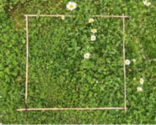 | 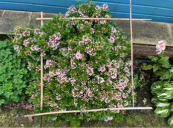 |
For the Pollinator Count, quadrats can be placed flat on the ground, over a flowering plant, or vertically against a flowering climbing plant.
More tips for your Pollinator CountMore tips for your Grassland Plant Survey